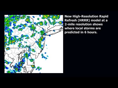
Today, meteorologists at NOAA’s National Weather Service are using a new model that will help improve forecasts and warnings for severe weather events. Thanks to the High-Resolution Rapid Refresh (HRRR) model, forecasters will be able to pinpoint neighborhoods under threat of tornadoes and hail, heavy precipitation that could lead to flash flooding, or heavy snowfall and warn residents hours before a storm hits. It will also help forecasters provide more information to air traffic managers and pilots about hazards such as air turbulence and thunderstorms.
Developed over the last five years by researchers at NOAA’s Earth System Research Laboratory, the HRRR is a NOAA research to operations success story. It provides forecasters more detailed, short-term information about a quickly developing small-scale storm by combining higher detail, more frequent radar input and an advanced representation of clouds and winds. The HRRR model forecasts are run in high-resolution every hour using the most recent observations with forecasts extending out 15 hours, allowing forecasters to better monitor rapidly developing and evolving localized storms.
“This is the first in a new generation of weather prediction models designed to better represent the atmosphere and mechanics that drive high-impact weather events,” said William Lapenta, Ph.D., director of the National Centers for Environmental Prediction, part of the National Weather Service. “The HRRR is a tool delivering forecasters a more accurate depiction of hazardous weather to help improve our public warnings and save lives.”
High-Resolution
Hyper-local forecasts are possible with the HRRR because of higher resolution. The HRRR’s spatial resolution is four times finer than what is currently used in hourly updated NOAA models offering a more precise prediction of a storm’s location, formation, and structure. Using the HRRR, forecasters have an aerial image in which each pixel represents a neighborhood instead of a city. “This increase in resolution from eight to two miles is a game-changer,” added Lapenta.
What Goes In…
The HRRR starts with a full three-dimensional picture of the atmosphere one hour before the forecast and then brings in observations from surface stations, commercial aircraft, satellites, and weather balloons to create a more detailed and balanced starting point for the forecast. Another key innovation for the HRRR is adding in radar data every 15 minutes during that hour to help the model “know” where precipitation is ongoing. Integrating atmospheric data gathered before a model run, including radar data at a two mile resolution, provides a more accurate picture of what is happening in the atmosphere at the start of the forecast. This helps predict changes to storms and development of new storms faster than current models.
…And What Comes Out
The HRRR’s hourly output includes more frequent snap-shots, in 15 minutes intervals, of the atmosphere. With this information forecasters can better anticipate and predict the onset of a storm and critical details of its evolution, allowing for earlier watches and warnings.
“The HRRR model will provide forecasters a powerful tool to help them inform communities about evolving severe weather,” said Stan Benjamin, Ph.D., a research meteorologist at NOAA’s Earth System Research Laboratory who led the research team that developed the model. “Being able to warn the public of weather hazards earlier and with greater detail is an outstanding return from NOAA’s investment in research and observation systems.”
Many NOAA scientists were involved with testing, optimizing, and implementing the model, including experts at NOAA’s National Weather Service and its National Centers for Environmental Prediction. NOAA’s partners at the Cooperative Institute for Research in Environmental Science at the University of Colorado at Boulder and the Cooperative Institute for Research in the Atmosphere at Colorado State University, Fort Collins helped with development. NOAA researchers partnered with users such as the Federal Aviation Administration, the National Center for Atmospheric Research, and the Department of Energy to significantly improve forecasts for aviation, energy among other industries through the HRRR model.
“Implementation of the HRRR is just one of many model improvements made possible with NOAA’s boost in its supercomputing power for weather prediction,” said Louis Uccellini, Ph.D., director, National Weather Service. “With advances in our forecast models, like the HRRR, we’re moving toward building a Weather-Ready Nation by improving our forecasts, providing better information to decision makers, and helping communities become more weather-ready and resilient against severe weather events.”
NOAA’s National Weather Service is the primary source of weather data, forecasts and warnings for the United States and its territories. NOAA’s National Weather Service operates the most advanced weather and flood warning and forecast system in the world, helping to protect lives and property and enhance the national economy. Working with partners, NOAA’s National Weather Service is building a Weather-Ready Nation to support community resilience in the face of increasing vulnerability to extreme weather. Visit us at weather.gov and join us on Facebook and Twitter.
NOAA’s mission is to understand and predict changes in the Earth’s environment, from the depths of the ocean to the surface of the sun, and to conserve and manage our coastal and marine resources. Join us on Twitter, Facebook, Instagram and our other social media channels.
More Stories
theHamStop.com Adds 2 New items
theHamStop.com introduces slotted products just in time for FieldDay 2025!!. The announcement from theHamStop.com of the release of theSkyHookx2x6S and...
Choosing a Portable All-Band Radio for Emergencies
After a recent conversation among friends over choosing a portable all-band radio suitable for emergencies....
theHamStop.com Introduces theCleatV
theHamStop.com has a new item in the shop just in time for 2024 Field Day!!. The announcement from theHamStop.com...
theCleatV and theSkyHookx3x8 are available
theHamStop.com has been at it AGAIN!! with 2 new products added to their inventory. The announcement from theHamStop.com of the...
Weather Season 2021
[caption id="attachment_9798" align="alignnone" width="598"] Earth a global map of wind, weather, and ocean conditions[/caption] Added a few new links to...
E-beam atomic-scale 3-D ‘sculpting’ could enable new quantum nanodevices
koi phys.org/news/2020-09-e-beam-atomic-scale-d-sculpting-enable.amp

